Tag Archives: Civil 3D

Civil 3D Fundamentals for Department of Public Works 2024- West Coast Time Zone

Objective: Designed for Public Works Departments who require Civil 3D® for interactive, dynamic design functions. Learn to utilize model-based tools to rapidly consider alternative plans. Learn techniques to organize project data, work with points, create and analyze surfaces, model road corridors, perform grading and volume calculations, and lay out pipe networks.

Prerequisites: A working knowledge of civil engineering or surveying as well as Microsoft operating system.
Experience with AutoCAD® or AutoCAD® based products (such as Land Development Desktop).

Date: July 14-18, 2025
Time: 8:00 AM – 5:00 PM PT
Duration: 5 days
Location: Online/Live Interactive Class
Deadline to Register: July 2, 2025

Civil 3D Interface
Import Survey Data
Style Management and Data Sharing

Surfaces
Alignments & Profiles

Assemblies
Corridors
Intersections

Introduction to Grading
Pipe Networks
Plan/Production Tools

Road Rehabilitation Projects
Introduction to Infraworks
Importing GIS data

If you are interested in inquiring about this training course, fill out the form below or call this number: 678-385-2185. A representative will reach out shortly.


Repro Products provides software, training, consultations and implementations of Autodesk solutions.  Click here to explore additional Autodesk solutions.

Civil 3D Fundamentals for Department of Public Works 2024 – East Coast Time Zone

Objective: Designed for Public Works Departments who require Civil 3D® for interactive, dynamic design functions. Learn to utilize model-based tools to rapidly consider alternative plans. Learn techniques to organize project data, work with points, create and analyze surfaces, model road corridors, perform grading and volume calculations, and lay out pipe networks.

Prerequisites: A working knowledge of civil engineering or surveying as well as Microsoft operating system. Experience with AutoCAD® or AutoCAD® based products (such as Land Development Desktop). Requires access to Civil 3D 2021 or newer with Civil 3D 2023.3 or newer recommended.

Date: July 7 – 11, 2025
Time: 8:00 AM – 5:00 PM ET
Duration: 5 days
Location: Online/Live Interactive Class
Deadline to Register: June 25, 2025

Civil 3D Interface
Import Survey Data
Style Management and Data Sharing

Surfaces
Alignments & Profiles

Assemblies
Corridors
Intersections

Introduction to Grading
Pipe Networks
Plan/Production Tools

Road Rehabilitation Projects
Introduction to Infraworks
Importing GIS data

If you are interested in inquiring about this training course, fill out the form below or call this number: 678-385-2185. A representative will reach out shortly.


Repro Products provides software, training, consultations and implementations of Autodesk solutions.  Click here to explore additional Autodesk solutions.

Civil 3D Best Practices for Public Works – In Person Seminar

Objective: Are you still using regular AutoCAD for your civil design projects? It may be time to take your workflows to the next level with Civil 3D. Already a Civil 3D user? Are you fully leveraging its powerful features to streamline your projects? And have you explored the additional tools available in the Autodesk AEC Collection that can enhance your design process?

Join us for an informative 2-hour seminar where we’ll dive into best practices and essential workflows for using Civil 3D efficiently. We’ll guide you through the entire project lifecycle—from initial survey data to final construction documentation—helping you optimize your workflow and increase productivity.

Date: June 12, 2025
Time: 10:00 AM – 12:00 PM ET
Registration Time: 9:30 am
Location: 4485 Atlanta Rd, Smyrna, GA 30080 (Our Smyrna Office) 

What You’ll Learn:

  • Civil 3D Essentials: Learn about templates, data shortcuts, GIS and LiDAR integration, road and pipe network design techniques, and best practices for creating construction documents
  • Beyond Civil 3D: Discover how InfraWorks can enhance your preliminary analysis and design, and see how Vehicle Tracking ensures proper swept path analysis—because ensuring a fire truck can navigate a new development is critical!

Whether you’re new to Civil 3D or looking to refine your skills, this seminar will equip you with valuable insights to work smarter, improve efficiency, and unlock the full potential of the Autodesk AEC Collection.

Don’t miss this opportunity to gain practical knowledge that you can immediately apply to your projects. Register today!

If you are interested in registering for this seminar, you can click the button or call this number: 678-385-2185. A representative will reach out shortly.

Repro Products provides software, training, consultations and implementations of Autodesk solutions.  Click here to explore additional Autodesk solutions.

Optimize Public Works Projects: Why Civil 3D Outperforms AutoCAD – Webinar

Date: May 29, 2025
Event Time: 2:30 – 3:30 pm ET
Presenting: David Young
Location: Online/Remote
Cost: Free

You’ve been using AutoCAD for decades to design infrastructure projects, but now it might be time to discover why Civil 3D could be the better fit.

AutoCAD® is a powerful drafting tool employed by many in the civil engineering field, but it has its limitations. Civil 3D® is a civil engineering design software package built on top of AutoCAD, but utilizing Civil 3D to its full potential can be a daunting task. Nobody said you must use all of it, though. Start small: crawl, walk, run.

In this Webinar, we will explore a few simple activities that are difficult or impossible in AutoCAD, but can be accomplished with just a few simple clicks using Civil 3D.

  • Maps and imagery using real coordinates
  • Utilizing GIS Data in your drawings
  • Importing Survey Points
  • Offset Alignments, Widenings, and Turn Lanes
  • Contours from Infraworks and Point Clouds
  • Profiles – Existing Ground and Design

If you are interested in registering for this webinar you can click the button or call this number to register: 678-385-2185

Repro Products provides software, training, consultations and implementations of Autodesk solutions.  CLICK HERE to explore additional Autodesk solutions.

Civil 3D Essentials For Public Sector Surveyors – East Coast Time Zone

Objective: Designed for government and public sector surveyors and survey technicians who utilize Civil 3D®. This course combines hands-on exercises with instructor-led lectures to develop practical, real-world skills. Participants will learn how to work efficiently within a government environment—importing field data, generating automated Existing Conditions Plans, performing traverse adjustments, and managing survey databases. Additional topics include point and surface creation, field-to-finish workflows, and GIS integration. Students will explore tools for survey data queries, connecting and importing GIS data and imagery, exporting to GIS formats, and best practices in CAD management principles.

Prerequisites: Experience with AutoCAD® and a basic understanding of surveying and related terminology are
required. Access to Autodesk Civil 3D® 2020 or newer is required, with Civil 3D® 2023.2 or newer recommended.

Date: June 9-11, 2025
Time: 9:00 AM – 5:00 PM ET
Duration: 3 days
Location: Online/Live Interactive Class
Deadline to Register: May 28, 2025

Civil 3D interface and templates
Survey databases and description keys
Linework entry and field book files
Traverse creation and adjustments
Point styles and management
Survey setup best practices

Connective codes and survey figures
Creating and importing points
Surface creation, editing, and volumes
LiDAR data for surfaces
Field-to-finish workflows
Least squares adjustments

GIS connections and data import/export
Survey data queries and analysis
Best-fit alignments and geometry tools
CAD standards: layers, linetypes, text
Layouts, viewports, plotting
Block creation and reuse

If you are interested in inquiring about this training course, fill out the form below or call this number: 678-385-2185. A representative will reach out shortly.


Repro Products provides software, training, consultations and implementations of Autodesk solutions.  Click here to explore additional Autodesk solutions.

Civil 3D Fundamentals for Department of Public Works 2024 – East Coast Time Zone

Objective: Designed for Public Works Departments who require Civil 3D® for interactive, dynamic design functions. Learn to utilize model-based tools to rapidly consider alternative plans. Learn techniques to organize project data, work with points, create and analyze surfaces, model road corridors, perform grading and volume calculations, and lay out pipe networks.

Prerequisites: A working knowledge of civil engineering or surveying as well as Microsoft operating system. Experience with AutoCAD® or AutoCAD® based products (such as Land Development Desktop). Requires access to Civil 3D 2021 or newer with Civil 3D 2023.3 or newer recommended.

Date: May 12-16, 2025
Time: 8:00 AM – 5:00 PM ET
Duration: 5 days
Location: Online/Live Interactive Class
Deadline to Register: April 30, 2025

Civil 3D Interface
Import Survey Data
Style Management and Data Sharing

Surfaces
Alignments & Profiles

Assemblies
Corridors
Intersections

Introduction to Grading
Pipe Networks
Plan/Production Tools

Road Rehabilitation Projects
Introduction to Infraworks
Importing GIS data

If you are interested in inquiring about this training course, fill out the form below or call this number: 678-385-2185. A representative will reach out shortly.


Repro Products provides software, training, consultations and implementations of Autodesk solutions.  Click here to explore additional Autodesk solutions.

Civil 3D Fundamentals for Department of Public Works 2024- West Coast Time Zone

Objective: Designed for Public Works Departments who require Civil 3D® for interactive, dynamic design functions. Learn to utilize model-based tools to rapidly consider alternative plans. Learn techniques to organize project data, work with points, create and analyze surfaces, model road corridors, perform grading and volume calculations, and lay out pipe networks.

Prerequisites: A working knowledge of civil engineering or surveying as well as Microsoft operating system.
Experience with AutoCAD® or AutoCAD® based products (such as Land Development Desktop).

Date: May 5-9, 2025
Time: 8:00 AM – 5:00 PM PT
Duration: 5 days
Location: Online/Live Interactive Class
Deadline to Register: April 23, 2025

Civil 3D Interface
Import Survey Data
Style Management and Data Sharing

Surfaces
Alignments & Profiles

Assemblies
Corridors
Intersections

Introduction to Grading
Pipe Networks
Plan/Production Tools

Road Rehabilitation Projects
Introduction to Infraworks
Importing GIS data

If you are interested in inquiring about this training course, fill out the form below or call this number: 678-385-2185. A representative will reach out shortly.


Repro Products provides software, training, consultations and implementations of Autodesk solutions.  Click here to explore additional Autodesk solutions.

Why You Need Civil 3D For Your Civil Engineering Projects

Civil 3D is a powerful software application developed by Autodesk that offers a range of advantages for civil engineers, surveyors, and designers. It provides users with a model-based environment, enabling them to make better design decisions and improve project quality.

Below are the benefits of using Civil 3D & why to consider our training:

Model-Based Design
Civil 3D offers a model-based approach to design, allowing engineers and designers to create 3D models of their projects. This makes it easier to visualize and test different design options, making it quicker to come up with the best solution.

Streamlined Documentation
With its design-driven approach to documentation, Civil 3D makes it easier to produce accurate and professional plans. By automating the documentation process, Civil 3D frees up time and resources that can be used for more important tasks.

Improved Collaboration
Civil 3D offers a powerful collaboration tool by harnessing the power of Building Information Modeling (BIM). This allows for greater design coordination and project collaboration, leading to a more efficient and effective project outcome.

Better Project Management
Civil 3D provides a range of project management tools that enable engineers and designers to organize their project data, work with points, create and analyze surfaces, create parcel layouts, model road corridors, perform grading and volume calculations, and lay out pipe networks. By using these tools, it becomes easier to manage projects and meet project deadlines.

Increased Efficiency
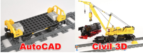
By using Civil 3D, engineers and designers can complete their projects faster and more efficiently. With its automated processes and tools, Civil 3D makes it easier to create and revise designs, helping to save time and money. In fact, a study commissioned by Autodesk found that Civil 3D allowed users to complete tasks up to 20 times faster than with AutoCAD!

In summary, Civil 3D is a powerful software application that offers a range of benefits to civil engineers, surveyors, and designers. By using this software, users can improve their project quality, streamline their documentation process, collaborate more effectively, and increase their efficiency.

If you’re looking to take your career to the next level, consider getting training in Civil 3D from Repro Products to learn how to use it to its fullest potential. These are live, interactive classes that are conducted online for your convenience. We also offer custom training as well as classes at your site using our mobile lab. If you have any questions don’t be afraid to reach out, by emailing marketing@reproproducts.com

Check out our 2 upcoming classes:

Click HERE for information about our West Coast class on April 10th.
Click HERE for information about our East Coast class on April 24th.

Civil 3D for Surveyors

Objective: Designed for Surveyors who require Civil 3D® for interactive, dynamic design functions. Learn to utilize model-based tools to rapidly consider alternative plans. Learn techniques to organize project data, work with points, create and analyze surfaces, create parcel layouts, model road corridors, perform grading and volume calculations, and lay out pipe networks.

Location: 4485 Atlanta Road, Smyrna, GA 30080

Course Length: 2 days (16 hours)


Connecting to GIS Data to show existing conditions
Points overview and styles
Importing points and coordinate transforms
Introduction to data collection in the field
Introduction to AutoCAD Civil 3D Survey and automated linework
Survey networks
Survey Least Squares analysis
Surface overview
Surface editing
Surface labels and analysis


Register Button

AutoCAD Civil 3D Tips & Tricks

Autodesk® AutoCAD® Civil 3D® helps civil infrastructure professionals improve project delivery, maintain more consistent data and processes, and respond faster to project changes, all within the familiar AutoCAD® environment.

This webinar will help improve your day-to-day operations when working with AutoCAD Civil 3D software. Join us as we show you numerous ways to help you get the most from your AutoCAD Civil 3D software investment.

Among the tips covered in the webinar are:

• Automating regular tasks
• Exploring underutilized features
• Capitalizing on several standard functions in new ways
• Discovering several useful undocumented commands